Reality Capture & Reconstruction
Laser scans, drone photogrammetry and Gaussian Splatting capture the site as it is. The 3D digital twin then reflects real conditions, not old drawings.
As-built accuracy
Specialist Digital Twin Service
We combine reality capture, BIM and live sensor data into an interactive spatial model. Teams can walk a site, find a fault and plan work without travelling there.
Air Handler AHU-4
Block C · Level 3 plant room
Remaining life
212 days
Supply air
14.6°C
Fan speed
68%
Filter ΔP
179Pa
✓ All signals within physics baseline
A 3D digital twin puts live operational data into the space where it happens. Instead of a list of alarms, your team sees a glowing pump in the right plant room, on the right floor, with a route to reach it.
Facilities, campuses, warehouses and plants hold thousands of assets across large footprints. Drawings are outdated, BIM files stop at handover, and sensor data sits in separate systems. People spend hours finding things that a model could show in seconds.
Our team builds spatial twins from reality capture, design models and live feeds. The result runs in a browser, stays current as sensors report, and gives remote experts the same view as the person on site.
A 3D digital twin is a geometric model of a physical place or asset, linked to live and historical data about it. Geometry answers where. Data answers what is happening and why.
The geometry can come from BIM and CAD files, laser scans, photogrammetry or newer neural methods such as Gaussian Splatting. The data comes from building management systems, IoT sensors, maintenance systems and documents.
What separates a twin from a 3D viewer is that link. Clicking a valve shows its pressure trend, its last work order and its manual. An alarm in the BMS lights up the right object in the scene.
Spatial context also changes how people collaborate. A remote engineer and a site technician can look at the same object at the same moment. Conversations that once needed photos, sketches and long phone calls take a minute.
Working definition
“A 3D digital twin is a spatially accurate model of a site, building or asset whose objects are linked to live operational data, records and workflows, so teams can understand and act on the physical place remotely.”
Foundations
Scans, BIM or CAD give a model that matches the built reality, not the original design intent.
Each pump, room and door has an ID that links it to asset registers and sensor tags.
Sensor values, alarms and states are drawn onto the right objects in real time.
Work orders, inspections and documents open from the object, so action starts where the problem is.
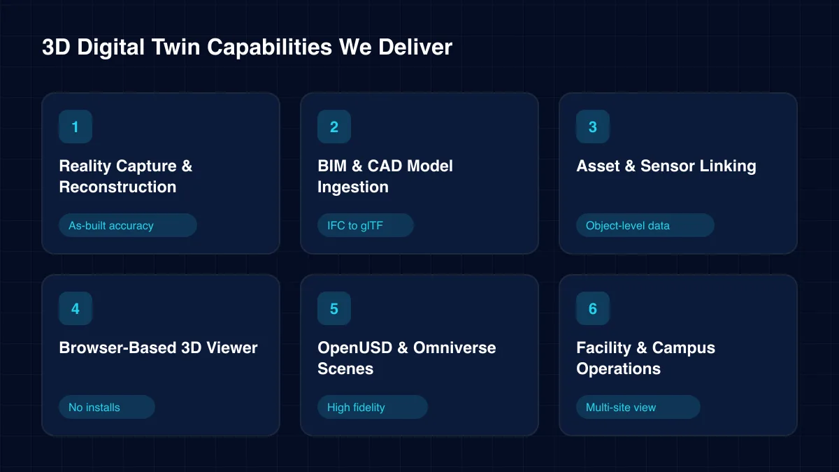
Core capabilities
Start with one building or one site, then add data layers and locations over time.
Laser scans, drone photogrammetry and Gaussian Splatting capture the site as it is. The 3D digital twin then reflects real conditions, not old drawings.
As-built accuracy
IFC and CAD models are cleaned, simplified and converted to web-ready formats. Object properties survive the conversion.
IFC to glTF
We map every modelled object to asset registers, BMS points and IoT tags. A click on an object in the 3D digital twin opens its live data.
Object-level data →Lightweight models stream to any modern browser. Heavy scenes use GPU remote rendering so tablets and laptops stay smooth.
No installs
For high-fidelity work, we build OpenUSD scenes in NVIDIA Omniverse. They support photoreal views and physics-based studies, such as lighting, sightlines or equipment clearance checks.
High fidelity →Room booking, energy, occupancy and maintenance views share one 3D digital twin of the estate. Facility teams manage many sites from one screen.
Multi-site view →Architecture
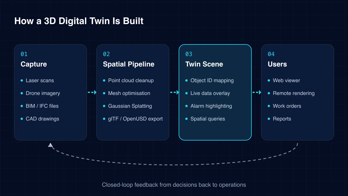
Geometry and data travel through separate pipelines and meet in the scene. This keeps each one easy to update.
01
02
03
04
Challenges we solve
These are the issues that make large estates slow and costly to run.
Renovations rarely reach the drawings. Contractors arrive with plans that no longer match the building.
Technicians lose time searching for valves, panels and dampers above ceilings or behind walls.
A BMS alarm names a point, not a place. New staff cannot tell where the problem actually is.
Experts travel for inspections that a good remote view could handle. Travel adds cost and delay. Small issues wait for the next scheduled visit instead of being fixed now.
Rich design models are archived after construction. Operations never benefit from them. Valuable object data about equipment, materials and warranties is lost to the people who run the building.
Energy, security, booking and maintenance tools each show a slice. Nobody sees the whole building. Decisions that touch several systems take far longer than they should.
Scale and fidelity vary by use case. We match the model to the decisions it must support.
A 3D digital twin is more than a pretty model. The table shows the difference.
| Capability | 3D viewer | BIM model | Spatial twin |
|---|---|---|---|
| Accurate geometry | Partial | ✓ Yes | ✓ Yes |
| Live sensor data | No | No | ✓ Yes |
| Matches as-built site | Partial | Partial | ✓ Yes |
| Opens work orders | No | No | ✓ Yes |
| Runs in a browser | ✓ Yes | No | ✓ Yes |
Spatial context speeds up almost every facility and site task.
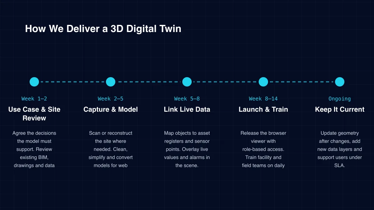
Delivery
Week 1–2
Agree the decisions the model must support. Review existing BIM, drawings and data systems.
Week 2–5
Scan or reconstruct the site where needed. Clean, simplify and convert models for web delivery.
Week 5–8
Map objects to asset registers and sensor points. Overlay live values and alarms in the scene.
Week 8–14
Release the browser viewer with role-based access. Train facility and field teams on daily use and gather their first feedback.
Ongoing
Update geometry after changes, add new data layers and support users under SLA.
Specialist services within our digital twin solutions practice.
Many studios make beautiful renders. A working twin needs data engineering too. Check these five points.
We recommend judging partners on a live data demo using your own site, not a showroom render.
Floor plans and plant layouts can expose security weaknesses. ICANIO works under ISO 9001 and ISO 27001 certified processes and treats every spatial model as confidential.
Models and data stay in your own cloud or on premises. Access is role-based, sensitive zones can be hidden per user group, and every view and export is logged.
Shared links expire, and public sharing is off by default. When contractors need access, our team creates time-limited roles that show only the areas of the 3D digital twin their job requires.
Count the hours technicians spend finding assets and the trips experts make for inspections. Those hours are the first saving a 3D digital twin targets.
Add faster contractor briefings, fewer surveys before projects and better energy decisions. We set these baselines with you during discovery and track them after launch.
In our experience, adoption is the hidden driver of payback. A model that field teams open every day saves far more than a detailed one that only managers visit.
Technology stack
We pick tools to suit the fidelity, scale and devices you need.
Capture
Laser scanningDrone photogrammetryGaussian Splatting360° imagery
Formats
IFCglTFOpenUSDPoint clouds
Rendering
Three.jsCesiumJSGPU remote rendering
Data
BMS integrationIoT sensorsTime-series store
Cloud
GPU instancesContainerised viewers
Workflows
CMMS work ordersDocument linksSSO access
A BIM model describes the design. A 3D digital twin describes the building as it runs, with live sensor data, alarms and maintenance records attached to each object.
Not always. Recent BIM or CAD files may be accurate enough. We check them against reality during the site review and scan only where gaps matter.
It is a newer method that builds a photoreal 3D scene from ordinary photos or video. It is fast to capture and great for visual context, but less suited to precise measurement.
Yes. We optimise models for web delivery. For very large or photoreal scenes, GPU remote rendering streams the view so the device only shows video. Field staff can open the 3D digital twin on site without special hardware.
Common sources are building management systems, IoT sensors, CMMS and asset registers, access control and energy meters. Each object in the scene can show data from several of them. Our team agrees the priority sources with you during the site review.
We set up a simple update path. Field teams flag changes, and our team updates geometry and links on a regular cycle as part of ongoing support.
How we deliver 3d digital twin and the wider digital twin practice in each sector.
A 3D digital twin makes large, complex sites understandable at a glance. It shows where every asset is, what it is doing and what needs attention.
ICANIO combines reality capture, spatial engineering, IoT integration and cloud rendering in one team. We start with one building or site, prove daily value, then extend the model across your estate.
By ICANIO Digital Twin Engineering Team · Published · Updated
Book a free discovery call with our spatial twin engineers. We will review your models and data, then outline a first site twin with clear milestones.
Contact Our Digital Twin Team